We can't find the internet
Attempting to reconnect
Something went wrong
Hang in there while we get back on track
£46.47
This is the usual price. Wait for it to drop, or tell us your number.
£46 today · usual range £37–£46 · best ever £37
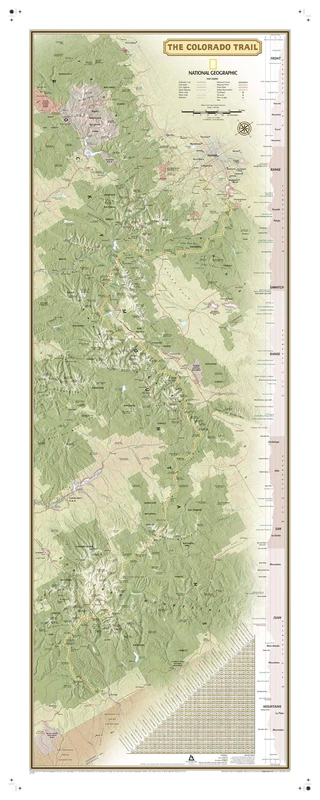
National Geographic Colorado Trail Laminated Wall Map (National Geographic Reference Map)
Multi
Price data last checked 33 day(s) ago - refreshing...
We'll watch every seller, every day. One email when your price arrives.
Price History & Forecast
Grey patches = out of stock. Cheaper = lower on the chart. Hover for exact prices.
Last 58 days · 58 data points (no recent data)
Multi
Price data last checked 33 day(s) ago - refreshing...
NEW HERE?
Amazon shows you one price. We show you all of them.
Tosheroon watches Amazon prices so you don't have to. Every product on Amazon has a price history — we make it visible. Set the price you'd actually pay, and we'll email you the second it gets there. No app, no account, one email.
WHAT'S ON THIS PAGE
when this has been cheap or pricey
where the price is heading next
all-time high & low, recent range
name your number, we'll email you
Price Distribution
Price distribution over 58 days • 2 price levels
Price Analysis
Most common price: £46 (30 days, 51.7%)
Price range: £37 - £46
Price levels: 2 different prices over 58 days
Description
Product Specifications
- Brand
- National Geographic
- Colour
- Multi
- Format
- map
- ASIN
- 1566957443
- Domain
- Amazon UK
- Release Date
- 15 March 2018
- Listed Since
- 03 January 2018
Barcode
No barcode data available
Similar Products You Might Like

Historical Atlas of the United States: With Original Maps
University of California Press
National Geographic Atlas of the World - 11th Edition
National Geographic

Best Easy Day Hikes Blue Ridge Parkway (Best Easy Day Hikes Series)
Globe Pequot Press

Geological maps: An Introduction
Springer
Wall map marker board: Austria physically large format 1:300,000
FREYTAG-BERNDT UND ARTARIA

Top Trails: Yellowstone and Grand Teton National Parks: 46 Must-Do Hikes for Everyone
Wilderness Press

2027 National Park Atlas & Guide
Rand McNally

Wall map magnetic marker board: Austria physical 1:500,000: AK 1 MMT
FREYTAG-BERNDT UND ARTARIA

Therm-a-Rest RidgeRest Classic Camping and Backpacking Sleeping Pad, Large - 77 x 25 Inches, Charcoal
Therm-a-Rest
The Natures of Maps – Cartographic Constructions of the Natural World
University of Chicago Press

Giant Book of Battle Mats Wilds, Wrecks & Ruins
Loke BattleMats
Wall map marker board: Austria organization political 1:500,000
FREYTAG-BERNDT UND ARTARIA

KOMPASS Bildband Die anderen Alpen: Wilde Landschaft, rätselhafte Plätze, alte Wege. 230 Entdeckungen in den Alpen: 1425

The North Face Unisex Trail Lite 65L Backpack, Granite Grey/Summit Nav
The North Face
Price unavailable
Scenolia Panoramic Poster Tapestry 4 x 2.70 m XXL HD
Scenolia
Price unavailable
Carved by Time: Landscapes of the Southwest
The Monacelli Press
Carte en relief du Mont Blanc et sa région : 1/210 000
3DMAP

Wall map marker board: Austria administration political 1:500,000
FREYTAG-BERNDT UND ARTARIA

Civil War Battlefields: Walking the Trails of History
Rizzoli

Trans-Canada Highway Straßenatlas 2026-2027: Millimetergenaue Karten, Provinzweiten, Routenführung, Sicherheitshinweise, Rastplätze, Nationalparks und Campingplätze von Victoria, British Columbia bis St. John's, Neufundland

The North Face Unisex Trail Lite 50L Backpack, Granite Grey/Summit Nav
The North Face

The North Face Unisex Trail Lite 50L Backpack, Granite Grey/Summit Nav
The North Face

AG Design Map Giant Wall Poster, Non Woven, Multi-Colour, 360 x 270 cm
AG Design

Wall map magnetic marker board: Austria administration political 1:500,000
FREYTAG-BERNDT UND ARTARIA